About Detector Maps
Detector Maps is the field tool that keeps you on the gold - and on the relics. Built by geologists for prospectors, relic hunters and metal detectorists across the United States, Australia, New Zealand and Canada, it...
Detector Maps is the field tool that keeps you on the gold - and on the relics. Built by geologists for prospectors, relic hunters and metal detectorists across the United States, Australia, New Zealand and Canada, it pairs geological data and historical maps with rock-solid GPS so you spend your time on high-potential ground, not guessing.
Whether you are swinging a detector for gold nuggets, coin shooting an old homestead, hunting Civil War relics or panning a creek, it puts serious research intelligence in your pocket - and it works offline, where the finds actually are.
COIN & RELIC HUNTING - NATIONWIDE
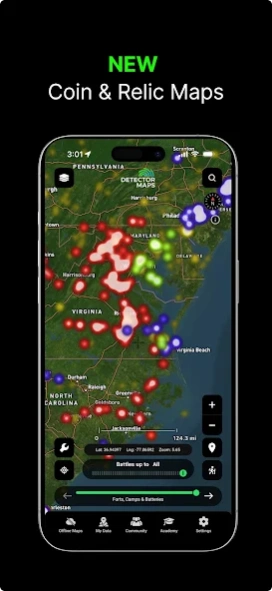
Research old towns, ghost towns, homesteads, schoolhouses and long-forgotten gathering places - the ground where old coins, buttons, buckles and relics are still waiting.
- Historical map overlays: hunt the buildings, roads and fields the modern map forgot
- Historic USGS Topo maps, coast to coast
- LiDAR that reveals cellar holes, old roads and house sites hiding under the trees
- Plan permissions with confidence before you knock
GOLD PROSPECTING - 15 STATES
Serious geology for nugget hunting, from California to the Carolinas. Detect where gold has already been found, then find what the old-timers missed.
- Historic gold mines, diggings and workings - proven gold ground
- Surface geochemistry with pathfinder-element filtering
- Current and expired mining claims, updated every weekday
- 1-metre LiDAR hillshade that reveals old workings worth a closer swing
DETECTOR ACADEMY
A built-in crash course: 34 short video lessons, most under a minute - layers, LiDAR, waypoints, trails, offline maps and Pro tools.
DETECTOR GRIDS
Plan complete, methodical coverage of a site with adjustable search lanes you follow while recording your trail - never grid the same ground twice.
BREADCRUMB TRAIL TRACKING (BACKGROUND GPS)
Record your exact trail even with the app in the background or the screen off. See where you have walked and save paths for the next trip.
WHY WE REQUEST "ALLOW ALL THE TIME" LOCATION ACCESS
Detector Maps only uses background location when you switch breadcrumb tracking ON, keeping an unbroken log while your phone is idle. Disable it anytime in the app or device settings.
WAYPOINT MARKING AND FIND LOGGING
Drop waypoints on coins, relics, gold finds and old workings. Add names, notes and photos, then sync securely between your phone and the web app so your finds are never lost.
REAL-TIME GPS NAVIGATION
Watch boundaries, geology, historical maps and terrain update around you as you move - a GPS built for prospecting, coin shooting and relic hunting.
COVERAGE
USA COIN & RELIC: Nationwide
USA GOLD: CA, AL, NC, AZ, NV, ID, OR, UT, CO, MT, WA, SC, VA, GA, NM
AUSTRALIA: QLD, NSW, VIC, WA, SA, TAS, NT
NEW ZEALAND: historic goldfields, geology and offline maps
CANADA: British Columbia
SUBSCRIPTION INFORMATION
All plans include every map, offline downloads, and access to Australia, USA, New Zealand, Canada (BC) and the UK.
USA Pricing - Explorer Monthly: $7.99 USD; Explorer Yearly: $59.99; Pro Monthly: $11.99 USD; Pro Yearly: $99.99 USD.
AUS/NZ/CA Pricing - Explorer Monthly: $9.99; Explorer Yearly: $99.99; Pro Monthly: $34.99; Pro Yearly: $249.99.
Payment is charged to your Google Play account at confirmation of purchase. Subscriptions auto-renew unless cancelled at least 24 hours before the period ends. Manage or cancel anytime in your Google Play account settings. Pricing may vary by region.
PRIVACY AND DATA
Privacy Policy: https://app.detectormaps.com/privacy-policy
Terms of Use (EULA): https://app.detectormaps.com/license-agreement
Whether you swing a GPX 6000, an Equinox, a Manticore, a Deus or a Gold Monster - or a sluice or a pan - Detector Maps helps you cover more ground, log your best finds, and read productive terrain like a professional.
Previous Versions
Here you can find the changelog of Detector Maps since it was posted on our website on 2025-09-09 18:00:42.
The latest version is 6.0.0 and it was updated on 2026-10-12 21:56:10. See below the changes in each version.
Detector Maps version 6.0.0
Updated At: 2026-09-21
Changes: Detector Maps 6.0, our biggest update yet.
• Android Auto: your map on the car's screen
• Drive there with voice directions, then walk in from where the road ends
• Trails rebuilt: live stats, pause, trim, replay your day as a video
• Automatic backups to your own Google Drive or OneDrive
• Historical maps free to view, added on a paid plan
• Cleaner popups and a layer info sheet
• Guided first run and in-app lessons
• Faster, smoother, many fixes
Detector Maps version 5.7.4
Updated At: 2026-09-16
Changes: What's new
• Faster start-up. The app opens in seconds even after a long Trail recording, and the map works while the rest of the recording loads.
• Smoother map with lots of saved Trails. They draw faster and no longer slow the app down.
• No more surprise logouts on patchy signal, like driving out of wifi range. You stay signed in.
• Cleaner launch. No more white flash when the app opens.
Detector Maps version 5.7.2
Updated At: 2026-09-11
Changes: - Trails now appear without selection
- Offline maps revamped
- Bug fixes
Detector Maps version 5.7.0
Updated At: 2026-08-26
Changes: - Bug Fixes
Detector Maps version 5.5.7
Updated At: 2026-08-07
Changes: - Export trails upgrade
- Bug Fixes
Detector Maps version 5.3.0
Updated At: 2026-07-06
Changes: NEW: Offline LiDAR (Premium) — download high-res LiDAR hillshade for any area and use it fully offline in the field. Coverage is checked before download, with live progress and a dedicated on/off toggle. Only California - more coming soon
We also rebuilt location tracking: a more accurate puck (consistent on Android & iPhone), more reliable trail recording with auto-resume, smoother follow-mode and better background tracking. Plus a faster map, JP2/PDF map import, My Data export and many fixes.
Detector Maps version 5.2.0
Updated At: 2026-06-20
Changes: Our biggest update yet.
New for Explorer (every plan):
• Image georeferencer — pin your own maps, old leases, scans or screenshots to real coordinates and hunt off them. Uploads to 1GB (GeoTIFF, PDF, PNG, JPG).
• Community maps — unlimited maps shared by fellow detectorists and prospectors, loaded into yours.
New region: British Columbia. New Zealand rebuilt.
New Pro (AU, BC, NZ): search exploration reports as a heatmap, plus daily tenement, claim and permit alerts.
Plus performance fixes.
Detector Maps version 4.4.2
Updated At: 2026-03-18
Changes: - Bug optimisations
Detector Maps version 4.4.1
Updated At: 2026-03-12
Changes: - Improvements and optimisations
- Gold pathfinder geochemistry elements
Detector Maps version 4.4.0
Updated At: 2026-03-02
Changes: - Added 50+ new USA layers to all 15 states
- Improved layer performance
- Updated legends and icons
- Enhanced popups
- UI improvements